Land Trust looking to keep North Shore country with Hawaii’s first greenprint
HALEIWA—The community on Oahu’s North Shore of Oahu is well known for coming together to protect the area’s land and to conserve the “country” feeling it’s known for. In helping to preserve those interests, it is the mission of the North Shore Community Land Trust (NSCLT) to protect and steward the natural landscapes, cultural heritage, and rural character from Kahuku Point to Kaena. Recently, the group has contracted the Trust for Public Land (TPL) to facilitate the first TPL greenprint to be done in Hawaii.
The TPL is a national, nonprofit, land conservation organization that conserves land for people to enjoy as parks, community gardens, historic sites, rural lands, and other natural places. Their process known as greenprinting is one of the TPL’s unique conservation services. The greenprint staff has worked with land trusts and government agencies to develop over 40 greenprints throughout the continental United States using community input to protect land.
“The greenprint project seeks to develop a conservation action plan that is based on community input to guide the NSCLT’s conservation work on the North Shore,” said Doug Cole, executive director of NSCLT.
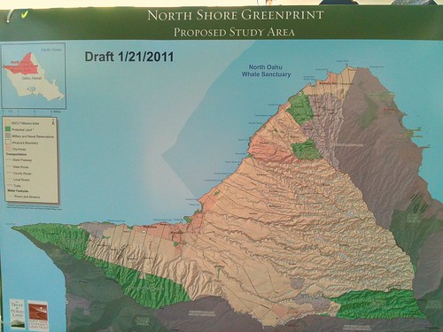
Greenprinting tools use a transparent mapping and modeling process to engage local residents in a thoughtful place-based planning exercise, focused on short term actions and long term vision. According to Cole, TPL will develop the greenprinting products, which include written materials and GIS based maps.
For more information on the greenprint process, contact NSCLT by clicking here
“Basically, we want to make sure that the conservation opportunities we pursue are part of a well thought-out strategy that the community helped establish,” Cole explained. “Because ultimately, we will need community support in order to successfully convert such opportunities into completed conservation transactions.”
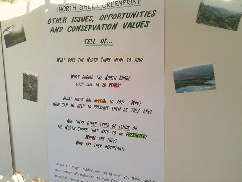
To gather community input, NSCLT held several outreach events, or “land protection talk stories,” at various outdoor markets in the area. At the North Shore Country Market, the Waialua Farmers’ Market, and the Haleiwa Farmers’ Market, both residents and visitors were given the opportunity to tell the organization what they value most about the North Shore.
Some key questions NSCLT asked community members at the markets were:
* What places are important to you?
* Why are they important?
* What values do they represent?
* How do we keep the North Shore a great place to live, work, and play?
Cole says the NSCLT has also been conducting in-person interviews with several different community stakeholders and they will continue them throughout the process.
According to Cole, so far a “few hundred” people have contributed their input and answered the questions provided at the outreach sessions. However, the feedback hasn’t yet been processed and tallied, and Cole says it’s too early to say what the most common visions are, or if there is one common theme in resident’s feedback.
“We hope to gather additional feedback before we identify what we believe are the shared values and priorities,” Cole said.
The Greenprinting process has several months to go before it is completed.
“I will do my best to keep the community informed throughout the process,” Cole said.
More on greenprinting
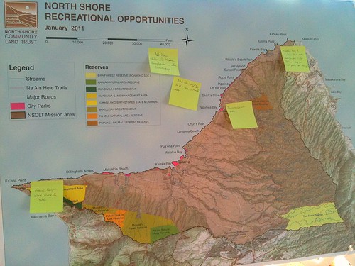
The TPL’s greenprinting process helps communities make informed decisions about land conservation, using computer models created with Geographic Information System (GIS) software to analyze community-based data. The TPL has developed GIS models that combine layers of spatial information to guide growth-management efforts. These efforts include:
Conservation Priorities—A community defines its own criteria for the lands it wants to protect. Its highest priority lands are then mapped on a greenprint.
Parks Gap Analysis—Mapping reveals which neighborhoods are most in need of parks and where land in those neighborhoods might be available to create parks.
Watershed Protection—By mapping stream buffer areas, slope profiles, soil types, and other data, greenprinting shows where land conservation can protect water quality.
Fragmentation Modeling—These models identify lands whose conservation would create continguous natural resources such as forests, wetlands, and wildlife habitat.
Trail Linkage—Greenprinting finds opportunities to link or expand existing trail systems.
Development Forecasting—Models project which lands—including important conservation lands—are most likely to be developed for commercial or residential uses.